Sunday, 10 June 2012

13 June, 2012 False Duck Island and Prince Edward Point Lighthouses

13 June, 2012 False Duck Island
and
Prince Edward Point Lighthouses

False Duck Island can offer some degree of difficulty, as would paddling to and from any Island approximately 5 kms off shore, in the great lakes. So Yes, getting the correct winds/waves means we go or don’t go, safety first. For us the best winds would be from the northwest 10km/h or less. Now we will go if the winds are from any direction 10 km/h or less. but we will need to start very early in the morning. Safety, we are very fortunate to have a safety net in Tim McCormack, a local commercial fisherman who moors right in Long Point Harbour near Prince Edward Point Lighthouse. His large fishing boat is made to handle Lake Ontario’s strongest sea’s. Thanks, Tim for your kind offer to be our guardian angel on this paddle. Let hope we do not have to call you…..

If winds do not look favourable we may change our paddle plan to Point Petre and Salmon Point Lighthouses. Again winds will play a key roll.

Saying all this, this week we need to be flexible in our paddle plans, we would not wish to cause anyone undo frustration or costs, therefore we are sorry this will not be an open paddle.

We wish to thank everyone who are following our lighthouse adventure and blog, we do ask everyone to support our local MS chapter at 613-384-8500

Thanks Rob & Mollie.

Thursday, 7 June 2012

6 June, 2012 Presqu’ile Point Lighthouse Visit


Presqu’ile Point Lighthouse Visit
6 June, 2012

Today our group met at the Flying J Truck Stop at Hwy # 401 & Hwy 41 at Napanee. Once all our group arrived, we headed west to Brighton and the boat launch located just outside Presquile Park at Harbour and Ontario St.

The Ford Paddle Group


 We love finding boat ramps like this one what a wonderful location to start our day’s paddle in and around Presqu’ile Bay.


Brent & Rob at Ramp


Presqu'ile Park in the background.


Nice kayaks, Rob setting his GPS


With in minutes Jane found the Geocache located at the Boat Ramp. Excellent.


Linda skirting up.


Thanks Linda for coming out, your amazing. Hamilton yesterday and paddling with us today.


Swan round up.


As we launched a family of Swans nesting very close by noticed us and , one of the parents trying to lead us away. With us all launched and out of their space, Rob kindly lead the one adult back to it’s family. It appeared not to be nervous, so we felt it knew he or she was going to be safe. Good job Rob.


Our paddle plan for the day was to explore the many bays along the east side of the park. Which meant paddling around Indian Point, then deep into several of the large swampy bays up to Calf Pasture Cove. Visit the Government Dock then round Salt Point, with it’s Sewer Pipe Light then onto Presqu’ile Point and the lighthouse. This is where we will meet Mollie for lunch. From the Lighthouse our paddle will take us back to Calf Pasture Cove pull out and Mollie would meet us to shuttle folks back to the boat ramp for vehicles. This did not happen we crossed Presqu’ile Bay to Shoal Point to visit a home made lighthouse which locals found very useful to navigate the bay. From Shoal we will paddle back north to Story Point around the channel light, then west past Gosport and back to the boat ramp. At the end of the day our GPS told us we did 15 kms. Great paddling with the wind picking up on the last leg of our trip west to the launch ramp.


Paddle Map route maked after paddle.


Remember: click on photo to enlarge it, twice makes it real big.


We did think about Murray Canal, however the dark skies, rain clouds, increasing wave height and the fact it would have added another 4 to 5 kms on to this trip changed our minds. My old paddle mentor pounded into my head prior my 10th year paddle trip, “You can never paddle in the afternoon, what you paddled that morning”. This has kept me in good stead, over the years.

One of many Swan Families


While paddling along the swamp area, we came across over 2 dozen Swan families. I had no idea that there where so many swans nesting in the park.


The young ones here are much larger


Ladies watching the swan in flight


Paddling out of the marsh through the reeds.  This was fun.


Rob paddling up to Government Dock


Our visit at the government dock was a nice shock. It docks are in great shape and used to this day. The Government Dock comes with a small green area, with washrooms located on what is called Cottage Road in the park. Nice lunch area.


Brent rounding Salt Point


What great colours blue on blue.


Linda showing group her find


Notice light behind the group.


As we rounded Salt Point we paddled between the sandy beach and the Sewer Pipe Light located just off the point.  It was here Linda noticed a structure of some kind in the shallow waters below us. After all of us waded in with our opinions, viewing on the camera the underwater photo’s we took, the group thought this was some kind of train tracks. I must admit I was sure of it, others not so much….smiling. Also after chatting with a park employee he seemed to think the same. WRONG!!!!!!!!!! Once again I could not resist exploring this mystery. 


From above this looks like a train track....smiling.


What looked to be railway tracks, turns out to be the hull of a schooner called the Minnie. What we thought were tracks, were tracks they used them in the construction of some older schooners for ballast and strength.


Here is what I found in the Great Lake Shipwreck register. 
MINNIE
Other names : none
Official no. : C none
Type at loss : schooner, wood
Build info : 1873, R. Anglin, Brewer's Mills, Ont.
Specs : 95x20x6, 109gc 109nc
Date of loss : 1877, Nov 2
Place of loss : 1 mi E of Salt Point, near Presqu'ile, Ont.
Lake : Ontario
Type of loss : (storm)
Loss of life : ?
Carrying : ?
Detail : Foundered.
Another Canadian schooner of this name was reported wrecked and total loss near Frederick Point, Lake Ont. Nov 10, 1880.
Hailed from Port Colborne.
Frames were made of Tamarack
Sources: mmgl,h,nsp not in '74 clu


What a great underwater photo, now you can see how the beams curl up.  How cool  this wreck is only 135 years old.  Good eye Linda, another little side adventure.

Presquile Lighthouse and lunch time


After this exciting find we paddle on to the Presqu’ile Point and the lighthouse.


Flag Photo


To our great surprise and pleasure the wind and waves where very light as rounded the point. Mollie was on shore waving us in. We did the flag photo thing with Mollie holding the MS Flag on shore below the lighthouse while the gang bounced around in the waters out front.


Perfect pull out just below the lighthouse,
very pretty


Mollie had found a wonderful pull out location for us, right by the gift shop and picnic area at the base of the light house. What a beautiful spot, the water turning deeper shades of blues the further it got from shore, waves rolling in over the grey granite rock on shore and the heat of the bright sun warming us. All this under the simple red light, which tops one of Lake Ontario’s oldest lighthouses. What a grand thing to share with good friends and family. Life is good.


Lunch on the shores of Lake Ontario under
Presquile Lighthouse as the sirens blast.


Then the sirens blew and blew and blew. One of the park employees came to open the gift shop/washroom building. Someone forgot to tell him the alarm code had been changed….smiling.   So this very loud siren blew for several minute while he called in and got the new code…The poor man.


First time we have eaten lunch at lunch time....


As they smile they are saying " turn it off,  turn it off " it was very funny.
The Happy Gang


After getting great group photo under the lighthouse. “Thanks Jane, your 10 second special was the best one again“,  but I could not use it.....At this time we have to thank the very nice gentleman from Peterborough for his kind donation. We hope you and your wife enjoy your new condo.


Just a nice picture....


Clouds were getting darker.


Goodbyes said to Mollie, she watched as the group paddled north heading into Presqu’ile Bay. 


This little lighthouse covers the owners water pump
How cool a pump house.


Our plan now was to meet Mollie at the pullout in Calf Pasture Cove, however I noticed the home made lighthouse the two ladies we met at the boat ramp earlier told us about across the bay on Shoal Point. I asked the group if we could paddle over and visit it, they all agreed it would be ok. What a cute little lighthouse really well made.


It was at this time Rob and Jane disappeared into that little bay…..Hummmmmmmm. Oh and Yes we did let Mollie know by radio we had changed our plans once again. We would now meet her back at the boat ramp we launched from that morning.  Ok, see you there, was her reply.


While crossing Presquile Bay to Shoal Point we chatted about heading into Murray Canal, just to the opening and look around. This was not to happen, as the wave height, and face on winds continued to increase. The group made the call to head directly back to the boat ramp which was about 2.5 kms away. We passed the Village of Gosport and a couple of small marinas and yes more Swans while watching the darkening clouds the whole time. 


Dark sky not shine us,  La la,   la la,   La


We did get a few drops, but nothing to really notice. As we pulled into the boat ramp the skies cleared and the sun provided welcomed warmth while we loaded our gear onto our vehicles. 


Wind in their faces, nasty skies behind them.


Paddle guys it's coming............


We made it before the storm. 

How fun was that ????


Today the group did really well, I know Linda could not get comfortable in her kayak on the last leg and Rob’s back was still giving him some pain from the day before. What troopers to still come out and paddle with us. I can’t thank everyone enough, Jane for her awesome photos, Linda and Rob paddling when not feeling at their best. Brent for being there with us, I know if I needed a strong swimmer he would be my guy and for all the help he provides the group. He is always smiling, as long as you feed him. Last Mollie, for always being our cheerful and very flexible shore crew. Your willingness to make last minute changes as we change plans on the fly, makes everyone’s paddle day so much easier. You are always looking after the best interest of the whole gang. We all love you. Thank You

All packed up we headed to Tim Horton’s, in support of Camp Day, great idea Jane & Rob. Next trip Ice Cream. What a great day. This will make the 19th official lighthouse visited on our listed. We have seen, paddled past and photographed many more lights for sure……….cheers. The things we have seen!!!!!!


Out Take Photo's


Once again Folks remember we are raising Awareness & Funds for the Multiple Sclerosis Society of Canada, Kingston Chapter. If you wish to make a donation/pledge please call the Kingston Chapter at 613-384-8500 . Tell them you wish to pledge to 20 Years To Enlightenment and it all stays in the Kingston and area.


Thanks Rob & Mollie

Monday, 4 June 2012

6 June, 2012 PresQu’ile Park & Lighthouse Paddle

PresQu’ile Park & Lighthouse Paddle
Possibly Murray Canal
6 June, 2012


If you wish to join us, this week we are meeting at the Flying J Parking lot Napanee exit Hwy # 401 at 08:30 Hrs. We will then head west on the Hwy # 401 to Brighton exit 509, then head south on Hwy # 30 through Wade Corners, Spring Valley and on to Brighton. Taking Hwy #30 straight through, which will turn into Prince Edward St till we turn right on Harbour St. At this point we can stop and figure out if we want to do the west end of Murray Canal.

Option # 1 ( Just the Park and Lighthouse )

Turn right on Harbour St. follow along the shore till we reach Ontario St. We then turn into the Public Boat Launch Area. There is no boat launch in the park. However they said they do have a dock for kayaks & canoes. Now if we launch here and follow the shore out to the Lighthouse to could be from 5.5 to 7 kms one way. Round trip 11 to 15 kms possibly, this depends on how much we explore, which we all like to do. We could then pull out at lighthouse it’s possible, but difficult.


Option # 2 ( Murray Canal )

If we choose this option, we will turn left on harbour till we hit Hwy # 64 turning right on Hwy # 64 till we hit the Canal Bridge at Lovett. This will then require a shuttle from Lovett to the boat launch at entrance of Park, which is on Ontario & Harbour St’s or in the park proper. We will then have a 3 .7 km paddle out of the Canal to Story Point, 2km crossing from Story Point to Indian Point which is in the park, then about 5 Kms along park shores to lighthouse. Then the 5.5 to 7 kms back to the boat launch. This could be a long paddle. Or we can do a pullout at the light which would mean a carry to the parking lot over a pretty rocky shore. Things to think about.


Drop us an e-mail or message and let us know if you will be joining us. We do not wish to leave anyone behind.

Cheers Rob & Mollie

Friday, 1 June 2012

30th May 2012 Rock & Sunken Island Lighthouse Trip


Rock & Sunken Island Lighthouse Trip
Upper Narrows, Wellesley Island New York
30th May 2012

Remember: click on photos to enlarge them

As for the norm on east bound trips, our group met at the Hwy #15 and 401 exit Park & Ride. As Brent and I pulled in at 08:20 we saw that the rest of the group had all arrived. So the first question out of the ladies in the group was, where is Mollie? Our number one shore crew. Sorry Linda, your travel buddy is enjoying the company of others today.
Before hitting the road I give Rob & Jane the other two way radio and our plan was to keep Linda in between us, this will ensure the group stays together. Arriving at the boarder, I feel confident that we have all the correct ID’s, Passports etc. You see Brent only had what we thought was the correct enhanced drivers licence. I guess this would not be a correct assumption, the shiny part on our licence does not mean it is the enhanced. Oop’s so after many intense questions a quick search in the back of the truck, the Customs Guard says to Brent I’m letting you in, but next time you “ will “ need a Passport to get in. After thanking him, we hit the road, “ Start the Car, Start the Car “ came to mind. With the complete group on U.S. soil we headed to our launch point at Fisherman’s Landing, Mullet Creek Bay public boat launch near Foxy’s Restaurant .

Off loading kayaks in Mullet Creek Bay
Boat Launch


With the kayaks off loaded we now shuttled our vehicles west to Bonnie Bell Marina, Alexandra Bay where Robin the office manager allowed us to park and use their launch ramp as our pull out point. Thank You very much Bonnie Bell Marina and Robin.


What a beautiful day, the water here is shallow
as you can see in this photo.


We zip back to Mullet Bay where Brent and Jane have been guarding our water transport. Within minutes the group was on the water heading north east passing the Isle Of Pines and into the Upper Narrows to Rock Island Lighthouse.


Lighthouse having major replairs carried out


This lighthouse will become beautiful again, once the needed construction taking place when we arrived, is completed. A very scenic location.


The group in flag shot mode.


I did a little photo shop stuff to this photo,  cleaned up the white and removed a worker from the walk way .....smiling.


Gananogue Boat Lines passing by.
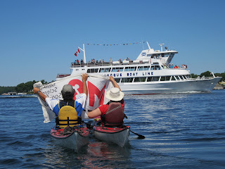
Rob & Jane doing the MS awareness thing.


These two never stop cracking me up!!!!
I think if they could have stopped the cruise boat and asked for donations, they would have......what a fun couple.


Linda getting that perfect photo we hope.


You know the group had to circle the lighthouse and Rock Island, to make sure we took photos from every angle, you never know when you can get that perfect shot.


Our planned route from Rock Island was to takes us east about 8 kms along the Upper Narrows to Sunken Island Lighthouse.   However, “ when you got to go, you got to go“ , so we started for Grass Point State Park, south east of Rock Island. 

Linda checking out the object.


On our way, Rob & Linda noticed something very large sticking up out of the water beside what we now know to be Mandolin Island.


Linda in the belly of this wreck


Well as we got closer, this object started to take shape, we could not believe our good fortune, it was a half sunken ship. 


The lads watched as Jane and Linda paddled right into the exposed steel rib hull.


Linda getting a close up. 


Rob had made a comment about the cement in lower half of the ship, interesting stuff.


Jumping here, you know I could not leave our shipwreck find just at that. This morning in the wee hours I finally uncovered the name of our ship. This is what I found after several hours of data mining :

General Hancock,” a tug boat of 131 gross tons: Official Number 228755 “S/S General Hancock,” 131 Gross Tons (89 Net Tons) 96.2 ft x 23.5 ft depth of 9.6 ft. Built in 1908 in Wilmington, Delaware as a ferryboat. Crew of four and 350 hp. Owned in 1935 by the Hutchinson Ferry Co., Ogdensburg, New York. Home Port was Fuller Street, Alexander Bay, New York. Note in the text that she was formerly the “USQM Corp General Hancock”.

I know how cool is this I found a photo of the ship.


If you read this and know any additional info on the General Hancock, like how it ended up on this tiny island near Rock Island lighthouse, please drop us a line……


Now on another site this is what they say:
Description: The "General Hancock" was built at Wilmington, Delaware for the U. S. Quartermasters Corps in 1898. She served as a ferry for Governor's Island. In 1929 to 1945, the "General Hancock" was owned by the Hutchinson Ferry Company of Ogdensburg, New York. This photograph was taken in 1940 at the Alexandria Bay  
Quarry Dock.


This ship number is the same on both sites, interesting Huh. There were three General Hancock ships over the years. I think the second site mixed up the facts and used some info from each site. Now which site is correct and how did it sink. This could be our mystery to uncover this summer. Feel free to help out.


Young guys they never have to pee, they just eat.


Back to Trip ...We made the park in good time, everyone took advantage of the amenities and we were back on the water in a few minutes, again heading east.


Headiing east in the Upper Narrows Channel
Ivy Lee Bridge ahead.

Our trip along the Upper Narrows was filled with beautiful homes/cottages/mansions. As we approached the Ivy Lee bridge our first of many Coast Guard/Border Security vessels slowly cruised pass us, checking to ensure we had all our safety gear. They did not stop us, I’m sure it was because we had everything visible, life jackets on, spare paddles & pumps on our decks etc. If only they knew we had Brent with us, the Alien.

Beautiful !!!!!


One of the many grand summer homes for the lack of a better name.  Just breath taking, the workmenship.  I can't begin to think what this estate would cost to maintain.


Just another awesome place.


This home was across the 100ft channel from the last one.


Just playing around, small bridge from one part of their island to the other.


Janes turn to go through, this is all part of
 Nobby Island


All of us in the group are just blow away at the size and grandness of these summer homes.


Along our route we passed wonderful places with names like Collins Landing, Swan Bay, St Lawrence Park, Point Vivian, Edgewood Park and then we entered the Manhattan Group. The Manhattan Group are a group of islands that surround Boldt Castle.


This was the home attached to the small bridge we all paddled under, notice the veranda, well inside is a mural of the 1000 islands on the wall. I don't know any more words for just frigging awesome. 


What can you say???????


Brent & Linda with the Boldt Castle Yacht House
in back.


Paddling on the north passage around St Elmo’s, Nobby Island and Heart Island were we came out looking at Boldt Castle’s Yacht House. Just beautiful, this magnificent build holds so much history, as does Boldt Castle itself.


Brent starter home....smiling


Brents starter home, it's small but in a real good neighbourhood.  This place is right up his alley, no grass to cut.


Jane & Linda taking in the sights.


This was the original entrance to the Castle. 


The three stage which are above the entrance arch. All brass. 


More of Boldt Castle.


The childrens play castle, at the east end of the island. 


This was where the border/customs guard
came out of to great us.


We then paddle to Boldt Castle and around it. Jane asked “ Do you think we could get out and have our lunch ?” We had the answer in the manner of a customs officer who met us at the dock as we approached. Yep they have a U.S. Customs Officer on Boldt Castle Island all summer. So with Brent’s lack of documentation we did not want to push our luck.


Jane checking out the childrens play castle, not Sunken Island Lighthouse to the left in the background. Not far to paddle.


The waves have come up a little all fun stuff.


Many photos later we turned our attention to Sunken Island which just happened to be about 300 meters southeast of Boldt Castle


Flag photo with group.


With a little wind at our backs it took us a couple of minutes to be at the lighthouse, taking photos in this open channel in this wind was going to be a bit of a challenge. Rob came up with the answer, by holding the flag up and letting the wind do it's thing, no group shot here.


Group fly by photo.


As this is a very small island we did not spend more then ten minutes checking it out.


Thinking calendar photo,
unless one of the group has a better one.


We now had to paddle into the wind south west to our pull out at Bonnie Bell which had to be no more the half a km away from Sunken Lighthouse.


Rob & Jane at Bonnie Bells boat ramp with Boldt Castle,
in the background, they were waiting for Linda & I
to return.


With the group landing safe and sound,  I drove Linda back to Fisherman’s Landing to retrieve her car. On our return the gang had the kayaks striped and had them ready to be loaded, within minutes we where making plans as to where to eat.


We all thought lets stop at the first park. Which turned out to be Keewaydin State Park.  Now at this time, I have to say sorry to Jane……….we did not get that Ice Cream, what happened there???


Lunch quickly devoured, we headed back to Canada. We made it across with Brent in tact. It was an awesome day, beautiful and bright, slight wind and currents in our favour, good paddle companions, life does not get any better that this. Thanks Jane & Rob, Linda and Brent you made this trip fun and interesting.


Once again Folks remember we are raising Awareness & Funds for the Multiple Sclerosis Society of Canada, Kingston Chapter. If you wish to make a donation/pledge please call the Kingston Chapter at 613-384-8500 . Tell them you wish to pledge to 20 Years To Enlightenment and it all stays in the Kingston and area.


Thanks Rob & Mollie